After exploring Beime’s backyard, I was excited when he recommended a hike behind my house. In fact, as a child I played in the ditch, looked up towards the bamboo grove, and wondered what lurked beyond the forest. I’ve gazed at the ridge, white rock, and “cross” many days wondering if it could be hiked. Well it can and today we did it.
Kawaewae is a three mile trail which begins on the “Friendship Garden” loop. Immediately Beimes and I walked up some rock stairs and veered left. (The right trail is the en route from the Friendship Garden loop.) Following were a series of switchbacks and soon another split. From research we knew to take the sharp left. A bit more trekking and the trail split for a third time. A kind lady who hikes the loop often recommended that we go left to the lookout. In deed there were beautiful views of Kaneohe Bay.
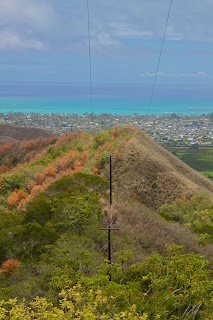
After a few pictures we turned around and headed off the Friendship Garden path to start the hike along the ridge. The trail got steep and some parts were accompanied by ropes which weren’t necessary on this dry day. However, the path was still slippery due to the loose dirt. After some huffing and at last a top the ridge we got more gorgeous sights of Kaneohe Bay, Kaneohe Town, and Kailua. Down the ridge we hiked passing a group of high schoolers painting the rock. We continued along to the next hump weaving through dense forests. Back down and back up we trekked. Finally we made it to the quarry where below we saw dump trucks and tractors hauling gravel, and a man made lake. It was surprising to realize that of all the times I’ve driven to Kbay I’ve never noticed or heard the work occurring.
Following an old water pipe up the final high point we climbed. Carefully we looked for the ribbon which we knew would lead us out. We feared missing it--which it frequently is but found it rather easily to our right. And...that's when the never ending descent began. The trail eventually curved right and near the bottom split. Beimes and I headed left on a jeep path, passed a house with posted signs stating “Trespassers will be killed” and walked along a fence hoping for an exit. The trail continued beyond what we knew so we back tracked and noticed the bright pink ribbons we somehow missed. Back on the marked trail we crossed a dry riverbed, and although the ribbons continued towards the starting point we followed the drainage to the road. Sure enough the path ended on Lipalu Place. A little less than two hours later and we were done. We walked back to my house which was much closer than Kokokahi Street.
Overall, the hike was mediocre. The best views were at the beginning so the remainder of the hike seemed rather monotonous. The ups and downs were tiring and although provided a good workout were not very rewarding. In additon, upon returning to my car my side mirror was broken, obviously hit by a passing car. The driver fled without leaving any information but fortunately the students who were painting the rock took down a license plate. I am not sure I will do this hike again, but I am definitely going to see if the ditch behind my house meets up with Kawaewae.
Directions: On Kaneohe Bay Drive, pass Castle High School on the right and then Bay View Golf Course on the left. After passing Kokokai YWCA on the left, turn right onto Kokokahi Street. Follow the road uphill until it bends right. The trailhead is on the left marked by the noticeable green “Friendship Garden” sign.


Pali Notches

Pali Puka


No comments:
Post a Comment