Friday, April 30, 2010

Oneawa Hills (Kawaewae)

After exploring Beime’s backyard, I was excited when he recommended a hike behind my house. In fact, as a child I played in the ditch, looked up towards the bamboo grove, and wondered what lurked beyond the forest. I’ve gazed at the ridge, white rock, and “cross” many days wondering if it could be hiked. Well it can and today we did it.

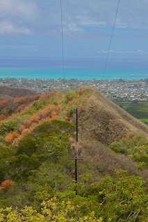
Kawaewae is a three mile trail which begins on the “Friendship Garden” loop. Immediately Beimes and I walked up some rock stairs and veered left. (The right trail is the en route from the Friendship Garden loop.) Following were a series of switchbacks and soon another split. From research we knew to take the sharp left. A bit more trekking and the trail split for a third time. A kind lady who hikes the loop often recommended that we go left to the lookout. In deed there were beautiful views of Kaneohe Bay. 
After a few pictures we turned around and headed off the Friendship Garden path to start the hike along the ridge. The trail got steep and some parts were accompanied by ropes which weren’t necessary on this dry day. However, the path was still slippery due to the loose dirt. After some huffing and at last a top the ridge we got more gorgeous sights of Kaneohe Bay, Kaneohe Town, and Kailua. Down the ridge we hiked passing a group of high schoolers painting the rock. We continued along to the next hump weaving through dense forests. Back down and back up we trekked. Finally we made it to the quarry where below we saw dump trucks and tractors hauling gravel, and a man made lake. It was surprising to realize that of all the times I’ve driven to Kbay I’ve never noticed or heard the work occurring.

Following an old water pipe up the final high point we climbed. Carefully we looked for the ribbon which we knew would lead us out. We feared missing it--which it frequently is but found it rather easily to our right. And...that's when the never ending descent began. The trail eventually curved right and near the bottom split. Beimes and I headed left on a jeep path, passed a house with posted signs stating “Trespassers will be killed” and walked along a fence hoping for an exit. The trail continued beyond what we knew so we back tracked and noticed the bright pink ribbons we somehow missed. Back on the marked trail we crossed a dry riverbed, and although the ribbons continued towards the starting point we followed the drainage to the road. Sure enough the path ended on Lipalu Place. A little less than two hours later and we were done. We walked back to my house which was much closer than Kokokahi Street. 
Overall, the hike was mediocre. The best views were at the beginning so the remainder of the hike seemed rather monotonous. The ups and downs were tiring and although provided a good workout were not very rewarding. In additon, upon returning to my car my side mirror was broken, obviously hit by a passing car. The driver fled without leaving any information but fortunately the students who were painting the rock took down a license plate. I am not sure I will do this hike again, but I am definitely going to see if the ditch behind my house meets up with Kawaewae.
Directions: On Kaneohe Bay Drive, pass Castle High School on the right and then Bay View Golf Course on the left. After passing Kokokai YWCA on the left, turn right onto Kokokahi Street. Follow the road uphill until it bends right. The trailhead is on the left marked by the noticeable green “Friendship Garden” sign.

Pali Notches

Pali Puka


Friday, April 23, 2010

Nualolo-Awaawapuhi

Sleeping Giant was fun. The Wet Cave better.
BUT the only thing I really wanted to do on this trip to Kauai was hike Nualolo-Awaawaphui Loop.

Nualolo-Awaawapuhi consists of five trails totaling 10.5 miles. Unlike most hikes, this loop begins with a descent, in fact a decline of about 2,000 feet, and ends with an incline. Yes, back up 2,000 feet. Although hikers can begin from either end most would agree that starting from Nualolo is easier since Awaawapuhi's ending incline consists of switchbacks and is therefore a gradually climb. Nu`alolo on the other hand consists of only a few switchbacks so if chosen as the loop's finish is much steeper. However, this also means that starting at Nualolo equates to a steeper descent which can be very taxing on the knees.

Nualolo is approximately 3.5 miles and ends at a junction where hikers can continue further to the Na Pali Coast via Lolo Vista (0.5 miles). Although some may bypass it, eager to start Nualolo Cliff, the view from the lookout should not be missed. After returning the half mile back in from Lolo Vista the trail heads left on Nualolo Cliff (2 miles). Here the trail winds through Nualolo Valley to the next junction on Awaawapuhi. There the junction's left trail, Vista (0.3 miles), is the lookout from Awaawapuhi ridge, and its right trail, Awaawapuhi (3 miles), is the final ascent back to Kokee Road. However, that is not all. Once completed hikers must walk 1.5 miles on Kokee Road back to Nualolo. Therefore, it is highly recommended that two cars be taken. No one wants to walk a mile and a half after trekking ten and half!
Due to our late start, Jaxon, Tiff, Cassie and I didn’t begin the hike until 11:00. Beginning near Kokee Lodge at an elevation of 3,660 feet, Nualolo's cool, well shaded and muddy trail took some maneuvering. Although we avoided the puddles, and fallen trees and branches we still took our fair share of slips. We laughed continuously at one another anticipating who would be the first to really eat it.

A mile later we made it out clean to a beautiful pasture like area. The descent continued towards the ocean. Down, down, down we walked until finally the trail's canopy opened giving us our first glimpse of the Na Pali Coast and Niihau.


Excited to see what other views were in store, Jaxon and I ran the remaining portions which were rather dry and rooty making it to the junction about an hour later. Patiently we waited for Tiff and Cassie. Five minutes. Ten minutes. After asking another hiker walking by we learned that one of the girls hurt their ankle so Jaxon left to check on the situation. Several minutes later he returned saying that Tiff tripped and fell, and although injured was on her way. Five minutes. Ten minutes. Still no Tiff and Cassie. This time I left but only to find Tiff sitting under a tree unable to walk. Although she didn’t look in much pain I told her that we had three options: 1) turn around and walk back, 2) continue and finish on Awaawapuhi which is longer but supposedly easier, or 3) walk half a mile to Lolo Vista where she could be medically evacuated. Tiff decided on option #3 so we headed to the junction. Trying to keep Tiff’s spirit high and in the least amount of pain I piggy backed her down some portions which was pretty hilarious stuff.


Junction


Back at the junction Jaxon and Cassie decided they would stay with Tiff and help her walk to Lolo Vista while I ran back out Nualolo to call for help. One hour and fifteen minutes later I was at Kokee Lodge dialing 911. Although I knew Tiff was fine and would be okay I was overcome with emotions. My voice quivered as I tried my best to explain the situation. Soon I was talking to the fire chief and then the paramedic. Initially I was advised to stay at the lodge to meet and then lead them in to Tiff. Fortunately the fire chief called back saying they would send a helicopter to medivac her out.
After a few more conversations with the rescue crew I was back on Nualolo. Halfway in I actually watched the helicopter air lift Tiff to safety and 45 minutes later was once again at the junction. I continued to Lolo Vista where I met up with Jaxon and Cassie. Knowing that Tiff was safe, we decided, actually I decided and they agreed, to complete the hike along Nualolo Cliff and Awaawapuhi. Jaxon and Cassie went ahead as I continued to Lolo Vista’s look out point not wanting to miss any views. The dry trail, gravely and uneven, made the path sketchy. In addition the signs warned about the loose ground that may wash out at a moment's notice, and although not vertical, the gradual drops were steep enough to end one's life. All of the above made the hike on Lolo Vista one that I did not take lightly. I trekked cautiously, contemplating the what ifs, and wondered how in the world Tiff made it out on this path with an injury. Yet, the anticipation filled me with exhilaration and excitement. The rewards definitely outweighed the risks.

A total of five hours and eleven miles (what should have been four miles) later I was finally at the look out some 1,400 feet above the Na Pali Coast. There to the left was Ni`ihau, to the right the Na Pali coastline, behind Nu`alolo Valley and its Jurassic Park waterfall, and just below the riverbed from the dry waterfall leading to the ocean.
Talk about unforgettable, unbelievable, stunning views.

I returned from Lolo Vista and continued along Nualolo Cliff meeting up with Jaxon and Cassie for a third time. The two mile trail snaked along a large washed out portion where a section of the right side of the mountain is caved in. Its fallen rocks covered the path making footing crucial. We also crossed three dry river beds. I can only imagine how beautiful the mini waterfalls must be during the wet season. From here the sights from within the valley toward the ocean were just as gorgeous!


At last we were at the second junction ready to began the ascent on Awaawapuhi, Nualolo's adjacent ridge. Luckily the trail was well shaded but the gradual inclines seemed never ending--maybe because it was monotonous or maybe because I was just utterly and completely exhausted. I prayed that behind each bend was the road.
Finally eight hours later we were back on Kokee Road but we still had to walk back to our car. Fortunately Jaxon stuck his thumb out getting us a hitch to the lodge which we didn’t know at the time was a mile and half away! Thinking about it, if we had to walk another mile after the SEVENTEEN I just completed I would have cried.
We drove back to check on Tiff who was resting at home. While there the Dr. called confirming that she had broken her fibula!!! And with both our phones dead Jaxon and I hurried home to Koloa where everyone awaited our safe return. I called my mom on Oahu who was worried as well. Needless to say everyone was glad that no one was seriously injured but...

We all can't wait for the next hike!


Thursday, April 22, 2010

Waikapala`e Wet Cave

After Sleeping Giant we headed to Waikapalae Wet Cave aka the Blue Room. About a 100 feet wide and 20 feet high, this particular cave has an unusual effect giving it its nickname the Blue Room. Towards the back-right of the main cave is an opening into another, smaller room accessible only by swimming.  The sunlight reflecting off the freshwater makes everything in the room turn blue, hence the name, Blue Room. 

Unfortunately, today it was cloudy so there was no sunlight to create the blue effect. The water lever was also unusually low, the lowest Tiff and Jaxon had ever seen. Although pretty bummed, I still had to take a dip. I promised myself after Jackass Ginger that as long as it was safe I’d get in any freshwater pond I went to. Maybe it was my head, but the water felt exceptionally cold. It didn’t help that no on else wanted to swim. I could not stay submerged longer than a minute so we quickly took pictures and left to sight see the rest of Hanalei.

After some research I learned that the cave was formed when the much higher ocean etched away at the lava rock creating the cave. The water in the wet cave comes from underground springs that eventually feed into the ocean.

Blue Room


Wooden Bridge

Hanalei Taro Fields


Nounou

Kauai is just beautiful. Literally gorgeous. Breathtaking.

I flew in on Thursday, and Jaxon, Tiff and I went straight to the Nounou better known as the Sleeping Giant. Basically consisting of a serious of switch backs we would have made it to the lookout in a jiffy, but confused by the downward path we turned around and headed left although the warning sign clearly pointed right. Now on the “old” path we found ourselves rock climbing and using the trees to pull ourselves up. Once again I told myself that if we made it to the group of trees just above it would meet up with the main trail. Sure enough after some sketchy hiking we were back on the established path. However, Jaxon hung over, dehydrated and about to pass out started puking on the side of the mountain. Pretty hilarious stuff considering the smack he was talking before the hike. 
“You’re never gonna talk shit about hikers again, yah?!” I told him.
“Nope,” he replied.
I smiled as I took pictures of his misery.
Jaxon continued up the mountain complaining the entire way and after another 10 minutes had enough.
Tiff and I ventured on and were at the lookout in less than 5 minutes. We took pictures and yelled for Jaxon but to no avail.
We worked our way down and what should have taken but an hour took two! TWO hours to complete an easy rated 3 mile hike!!! 

Should've listened to the sign..."For you safety stay on the established trail"

Left trail

"King Kong" in the distance


Directions: Heading north towards Kapa`a, turn left onto Hakelilio Road. As the road bends left, a small paved parking lot will appear on the right along with the state trailhead sign.

Saturday, April 10, 2010

*Ahuimanu*

Thanks so much to Beimes we got to explorer Ahuimanu...

Zeke and Zeph had a blast climbing, sliding, discovering, and getting dirty! I think we came across a heiau, then followed a stream to a “crack” in the Koolau Mountain face, and ventured up the slope to the left of the wall to see what it offered. It soon got too steep, to the point where Zephen couldn’t take a single step without slipping. A bit paranoid I decided to stop while Beimes continued up. He was able to see the ocean but unfortunately the trail led to nowhere. We exited the hike using a different path and luckily it was much more prominent than the one in. It was fun to finally be back in the mountains!

Until our next venture down a different trail...

love the background!